Remote Sensing Services
We are at the dawn of a new era. Now, many complex, difficult, and often dangerous tasks can be done with the help of autonomous, remotely guided systems. More importantly, data on a physical environment can be gathered, experienced, manipulated, and analyzed without disrupting the ‘real world.’ It’s the data equivalent of ‘leave no trace’ and its possibilities are endless!
Unmanned Aircraft Systems (UAS), as an example, let organizations use Unmanned Aerial Vehicles (UAV) to access hard-to-reach locations, collect data on critical infrastructure, survey and map urban and remote areas, and speed up and increase the accuracy of data collection. Just a few of the many ways UAVs can create a visual representation of a physical location include:
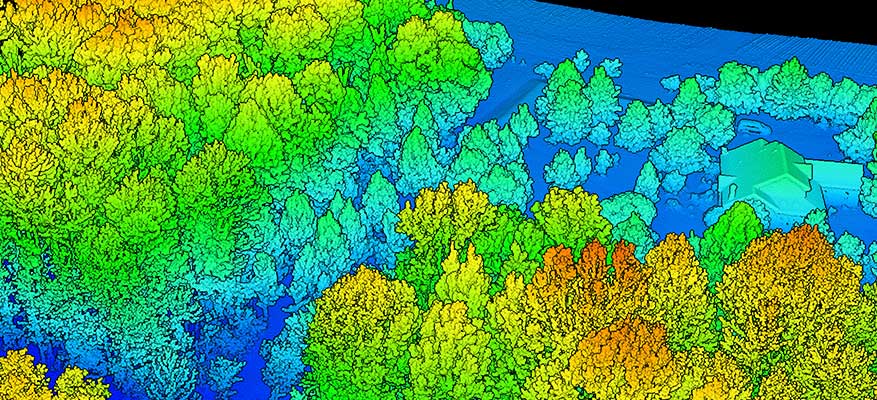
- LiDAR (Light Detection and Ranging) to create accurate 3D maps and models
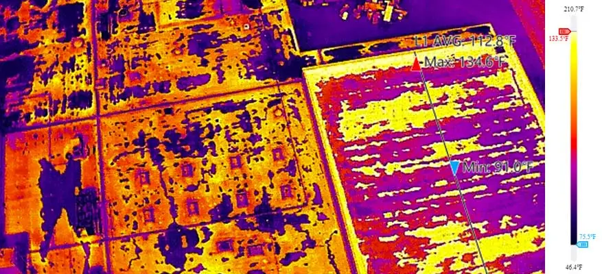
- Thermal imaging that creates detailed heat maps
- Ground Penetrating Radar (GPR) to detect and map underground features and locate buried objects and structures
Critical Ops believes an effortlessly autonomous world is possible. Our mission is to use autonomous platforms such as UAS to challenge legacy processes and reduce complexity, improve resource allocation, and provide deeper insights for organizations by utilizing a true and unbiased “view from above.”
The possibilities for UAS are virtually limitless. Here are just some of the ways Critical Ops’ Remote Sensing Services can be woven into your organization’s DNA:
UAS for Data Collection
- Surveying and Mapping, such as topographic mapping, 3D modeling, and volumetric measurements can improve your planning, resulting in cost savings and higher margins.
- Infrastructure Inspections to detect damage, structural wear and tear, or anomalies, reducing manual requirements, issuing faster diagnoses, and creating opportunities to prioritize repairs. Infrastructure examples include solar panels, levees and dams, power lines, pipelines, and bridges.
- Environmental Monitoring on wildlife populations, vegetation, and harmful emission tracking can provide improved planning data for end-user organizations, including environmental agencies and research firms.
UAS for Land Management
- Land Use Planning provides visual information for design-build projects, resulting in better decisions on feasibility of site selection.
- Development Support monitors construction progress and conducts compliance checks, resulting in vastly improved compliance monitoring data.
- Procurement Support includes accurate estimates, real-time data acquisition, enhanced site survey efficiency, and reduced human error, leading to more informed decision-making and cost savings.
UAS Education and Outreach
- Technology Integration into Business Operations, including actionable workshops and process realignment for organizations integrating UAVs into their operations.
- Usage Workshops covering UAV regulatory knowledge, flight skills, safety procedures, and specialized applications.
- Education Programs, workshops and events focused on STEAM fields can encourage students to pursue these in-demand careers.
SENSORS & SERVICES
LiDAR
Ideal for large sites, rough terrains, or when detailed elevation data is needed.
Horizontal Accuracy:
± 5 cm at 150 meters
Vertical Accuracy:
± 4 cm at 150 meters
240-600 points per sq/m
Vegetation penetration
Scan 10,000 sq/m in under 30 minutes
GPR
Identifies buried utilities, structures, and geological features, particularly in rugged, hazardous, or limited access areas.
Operating Bandwidth:
50 – 150, 75 – 300,
150 – 600 MHz (-12 dB)
Frequency Range:
50 - 400MHz
Depth:
Up to 12 Meters
THERMAL
Ideal for electrical inspection, water leaks,
hidden fires and hot spots, and wildlife research.
Temperature Measurement Methods:
Spot Meter, Area Measurement, and Center Point
Scene Range:
-20 deg. Celsius to
1600 deg. Celsius
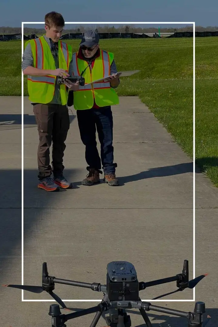
OUR PILOTS
All pilots are
Part-107 certified.
Approved to fly
in most restricted airspace.
All missions are approved in the FAA UAS Data Exchange system, LAANC.
Fully insured commercial operators.
Zero safety incidents.
PRIMARY INDUSTRIES
CONSTRUCTION
• Construction surveys
• As-built 3D models
• Job site inspections
• Stockpile measurement
• Earthwork cut-and-fill estimates
ENERGY
• Turbine inspections
• Solar inspections
• Power-line inspections
• Tower inspections
• NFPA 70B compliance inspections
OIL & GAS
• Well-site inspections
• Offshore-platform inspections
• Pipeline inspections
• Facility-build monitoring
• Emergency monitoring
Our commitment to integrating cutting-edge sensor technology into your operations ensures unparalleled access to data-driven insights, whether for infrastructure management or environmental monitoring.
With the ability to navigate difficult terrains and turn data into visuals, we help organizations achieve higher productivity and safer operations. And if you prefer the raw data, not a problem—we can translate it into an image or simply provide the raw outputs directly.
Let Critical Ops be your trusted advisor and partner for Remote Sensing Services. We’ll provide safer, more versatile, reliable, and less expensive ways to collect and analyze data so you can make better decisions.
Real-World Proof Points:
Improving the resilience and reliability of our energy infrastructure.
How:
- Conduct above- and underground analysis of energy transportation (oil, gas, and electric)
- Implement an environmental impact program that includes site selection and corridor services
- Establish a sensor-based inspection program of physical and operational conditions of the infrastructure and identify anomalies
- Implement a rapid response team for emergency drone inspections and monitoring
Increase UAS flight adoption through training, education, and outreach.
How:
- Provide industry-specific UAS education and training for professional users, from beginner to advanced levels covering safety, regulatory compliance, and industry-specific best practices
- Establish UAV-based activity programs for youth through adult level that include workshops, camps, and competitions
If the future is something you haven’t even thought of yet, Critical Ops can help integrate Remote Sensing Services into your business strategy. Give our seasoned professionals 30 minutes to learn about your organization and we’ll help you fearlessly face the future.